Floodway Property Development for Norwich, CT.
Recommendations for commercial uses of brownfields sites within flood zones of Norwich, CT.
2019

Norwich Imperious Surface Disconnection Strategy
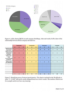
A Climate Corps team worked with the City of Norwich Public Works Department to devise a strategy for disconnecting 2% of the City’s impervious cover. The 2% disconnection is a requirement of the new General Stormwater Permit (also called the “MS4” permit) issued by the state under the provisions of the Clean Water Act. The team analyzed the type, amount and location of impervious surfaces in town, and developed strategies for how the City could prioritize approaches to disconnection.
For Citation Purposes: Connecticut Sea Grant & University of Connecticut’s Center for Land Use Education and Research. (June 7, 2018). City of Norwich. https://climate.uconn.edu/climate-corps/projects/town-projects/norwich